Saturday, December 22, 2012

Mesa Verde New Visitor Center


The new Mesa Verde National Park Visitor and Research Center opened for visitors in mid December 2012. It is located just outside the main park entrance and there is no charge to enter.

For visitors, it provides an introduction to the park and includes tickets for the main tours and a bookstore. The Chapin Mesa Museum continues as the main place to see artifacts and detailed explanations.


One of the displays inside the entrance discusses the steps taken to make this new facility a very green building. Emphasis was placed on conserving energy and water, and using environmentally friendly materials. The building is highly insulated and has large windows that capture solar heat in winter but prevent heat loss. Photovoltaic panels capture sunlight and convert it to electrical power.


The Ancestral Pueblo archaeology introduction uses a format of the questions of Who are we? Why were we here? How did we live here? And where are we now? The how did we live here segment has the most eye catching display. On one side there is a figure climbing hand and toe holds.


Below the climber, a woman at a seep spring uses a pottery dipper to transfer water to a pottery jar. All of the interpretive signs provide tips where in the park you can see real examples of the images depicted,  such as actual seep springs with similar small chiseled basins.


The opposite side of the same display shows a stone worker shaping one of the many sandstone bricks needed for the extensive structures. The development of masonry and building styles is one of the most amazing aspects of Mesa Verde.


The Where are we now exhibit shows a map of where current pueblo people live. One of the main questions about Mesa Verde is what caused the burst of alcove building in the 1200s and why did the Ancestral Pueblo people then abandon the area so abruptly about 1300 AD.

This exhibit includes some audio samples of the languages that are now spoken by Pueblo people. Four different Pueblo languages are mentioned plus the Navajo language.


Most of the new facility is devoted to research and storage of artifact collections. There are large windows that provide a glimpse into the facility but the view is mostly of cardboard boxes. There is a computer display near the windows that provides some information on the types of materials that are stored here.


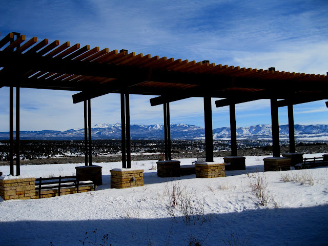
On the north side of the new Visitor Center there are large ramada shaded areas and benches with good views toward Mt. Hesperus and the LaPlata Mountains. My visit was in late December about 9 days after the opening. Despite the winter conditions there was a steady flow of visitors.

Sunday, September 23, 2012

Hike and Bike on Wetherill Mesa


Wetherill Mesa at Mesa Verde has the second largest concentration of Ancestral Pueblo ruins sites in the park, but is usually only open in the summer season between Memorial Day and Labor Day.

The southwest Colorado National Park held a special Wetherill Mesa Hike and Bike day on September 22, 2012. The Wetherill Mesa Road was open to entry from 9:00 AM to 3:30 PM with all visitors leaving by 4:30 PM.


The 5.4 mile paved tram road is open for hiking and biking to the several sites. Visitors park at the information kiosk as usual, and then set out on the tram road or the normal hiking trail. Staying on the tram trail, the first attraction is the 1 mile round trip Nordenskiold Site #16 Trail. 


The Nordenskiold Trail leads to a lookout point of the No. 16 site that features about 50 rooms and 5 or 6 kivas. This site has a round tower on the right side and perhaps a squarish kiva on the left side. There is a site diagram on the interpretive sign at the overlook point.


A small ruins site in visible with binoculars across the scenic Rock Canyon when looking to the west from the same viewpoint.


Long House is a good place to visit on the Hike and Bike days. The hike along the tram trail to the Long House trailhead is about 0.75 miles and takes me about 20 minutes if there are no other stops. Normally, visitors arrive on the tram and hike in groups of up to 60 with no little opportunity to pause along the trail and take in the views or examine the Pinon Pine and Utah Juniper forest.


This is a good opportunity to notice Long House details that might normally be missed. I noticed a doorway on the right side of the large Long House site that seems to have an inside stairway leading down to it.


In the same area I noticed a T-shaped doorway. There is some mystery about this type of doorway. Is it practical or does it have some symbolic meaning.


After visiting Long House, I returned on the tram road and walked back to the busy kiosk. As part of the special day, a hamburger or hot dog and chips lunch was available at the kiosk for $5 or $6. My hike and visit to the Nordenskiold Trail and Long House took 2:30 hours for about 4 miles of walking. It was an 80 F degree late September day and there were dozens of other visitors enjoying the day.


Friday, September 7, 2012

Inside Mesa Verde Square Tower House


During the 2012 season at Mesa Verde National Park in southwest Colorado, ranger guided hikes into the Square Tower House site were offered on Tuesdays, Thursdays and Saturdays from May 26 to June 16 and from September 4 to October 6. These tours start at 8:00 AM and last about 2 or 2.5 hours. There is a $25 charge and reservations have to be made. Each tour is limited to 10 hikers.


Square Tower House site was occupied from the mid 1100s to the late 1200s. The site contains about 49 rooms and 8 kivas. The eye catching structures are the 28 foot tall Square Tower and the Crow’s Nest high in a crevice.


The Square Tower House alcove isn't as deep as some of the other large sites at Mesa Verde. This might explain the exceptional height of the Square Tower House. The builders were forced to build upwards to add more rooms.

On the left side, there is a rebuilt section against the back of the alcove that was supervised by Jesse Walter Fewkes in 1919 to prepare the site for visitation by the public. Square Tower House was visited by the public in the 1920s and 1930s but has been visible only from the overlook until tours resumed in 2011.


From the right side view it appears that the all but the top floor have entry ways on the front and the right side. It also appears that there were balconies on the right side.


The lowest levels of the Square Tower have some T-shaped doorways. This is the tallest structure in Mesa Verde.

Like many of the large alcove sites at Mesa Verde, the builders incorporated the naturally occurring boulders into the structures.


Our group of 10 spent a total of 2:30 hours visiting Square Tower House on an early September morning. It was comfortably cool 60 F degrees at 8:00 AM and most of the hike is in shade.


Around the corner from Square Tower House is the seldom seen Little Long House. The 2011 and 2012 Square Tower House tours haven’t gone there but probably could.


 Little Long House is supposed to have a better source of water than Square Tower House.

(There is another post on Square Tower House that shows more of the overall features. Use the labels Square Tower House Guided Hike to find.)


Sunday, August 19, 2012

Spruce Canyon Trail on Chapin Mesa


The Spruce Canyon Trail is one of two 2.4 mile trails, along with the Petroglyph Trail, that start at the Spruce Tree House trail head next to the Chapin Mesa Museum in Mesa Verde National Park in southwest Colorado.


From the trail head paved switchbacks descend into the canyon to Spruce Tree House, one of the major Ancestral Pueblo Ruins sites that can be entered. It is possible to hike the Spruce Canyon Trail without passing by the ruin site, but it is a spectacular site and is worth a look even if you've seen it before.


After splitting from the Petroglyph Trail, the Spruce Canyon Trail descends with switchbacks to the bottom of the Douglas Fir dominated side canyon continues south for a short ways then swings north around a canyon junction into the main part of Spruce Canyon. The trail is smoother walking than the nearby Petroglyph Trail. The elevation at the trailhead is about 7000 feet and the descent on the Spruce Canyon Trail is about 500 feet.


The canyon bottom is dense forest of mostly Gambel Oak with Douglas Firs. There are views of the canyon sides in some places. I scanned the canyon walls for small ruins sites with binoculars but didn't see any. There is a medium sized ruins site along the trail but it isn’t visible from the canyon bottom.


Climbing back to the canyon rim there are signs pointing the way back to the Chapin Mesa Museum, but there are interesting features along the rim.


The picnic ground close to the rim was the original park campground and there are views of where you were just hiking.

Continuing along the rim the trail passes Fewkes Cabin, named for Jesse Walter Fewkes, the pioneer archaeologist who did much of the early work in Mesa Verde. Fewkes was an early proponent of opening the ruins sites to the public as an educational experience. This is the oldest historic building in Mesa Verde. Further on is the original amphitheater. There are still cultural presentations here.


The trail continues past the old amphitheater to the edge of the overflow parking lot where you can scan the cliffs across Spruce Canyon to the west with binoculars. There is a medium sized ruins site just below the rim, over the Spruce Canyon Trail. There isn't a sign pointing this site out and it doesn't appear on the park map. The Park Rangers say that this site is called Thomas House. Thomas House has a T-shaped door visible.


Further on, at the tip of the mesa top, the routes for both the Petroglyph Trail and the Spruce Canyon Trail are visible. My hike took 1:50 hours on an 85 F degree mid August day.

18407_$5 Shipping on Orders of $99 or More! 544544_$20 off any hotel booking of $350 or more with code TLSALE20

Monday, August 13, 2012

Spruce Tree House Ruins Trail


Spruce Tree House at Mesa Verde is the third largest cliff dweller ruin and is a favorite as it is located near a variety of visitor services including the Chapin Mesa Museum, gift shop, and food service.


There is a paved trail leading down into Spruce Tree Canyon. This trail also is the starting point for the Petroglyph Trail and the Spruce Canyon Trail. Many of the common plants growing in the canyon are also identified along the paved trail. There is a trail guide available that provides interpretation for the site. Many of the plants along the trail are identified with comments on their possible uses.


The first courtyard represents an area where people lived and worked on good weather days. The three story wall fronts about 20 rooms accessed through the rectangular and key hole shaped openings. There is a layer of soot on the cave ceiling and a kiva in the foreground.


Kivas are thought to have been the center of spiritual activity and also as a work area and social gathering place. They are designed to give good ventilation, as opposed to the other rooms. Fresh air was drawn in through a ventilation shaft and deflected around the room. Roof beams were supported by the six pilasters distributed around the circle. There appears to be eight kivas as part of the Spruce Tree House site. Three of the Spruce Tree House kivas have reconstructed roofs and one can be entered.


The section on the right is one of the rare places where some modern reconstruction was done to prevent further collapse. Most of the sites have only had some minor work done for stabilization.


The view that the people had living here while standing in the plaza was pleasant, very green and sheltered, with the tall Douglas Firs looming overhead. A small spring provided water for this site and aided the plant growth.


There are two historic inscriptions to look for at Spruce Tree House. The Nordenskiold No. 1 is found near the left rim of the kiva that is discussed at stop 6 on the self guided tour. Nordenskiold was the first scientist to examine Mesa Verde Cliff Dwellings in 1891. The Nordenskiold No. 15 is easy to see at Long House on Wetherill Mesa. One of the short trails on Wetherill Mesa is named the Nordenskiold No. 16 Trail, but the inscription isn’t visible. 


Near the right end of the alcove the John Wetherill initials JW are visible. John Wetherill ranged far in the Four Corners area and left initials in many locations.


Thursday, July 26, 2012

Petroglyph Trail Canyon Views


The interpretive Petroglyph Trail travels a 2.4 mile loop below and above the rim of Spruce Canyon in the Chapin Mesa area of Mesa Verde National Park in southwest Colorado.. The trailhead is at the Chapin Mesa Museum and begins with the paved descent to Spruce Tree House. When hiking in the morning, most of this hike is in the shade of the cool canyon.


There are 34 stops along the trail, emphasizing the plants of the canyon and mesa top and their possible uses to the people and wildlife that live here. The main trees are Pinon Pines, Utah Junipers, and Gambel Oaks with Douglas Firs in the cool shady parts of the canyon. 

The mix of shrubs can vary with subtle factors such as facing north or south and the soils. Most of the shrubs that occur at Mesa Verde are pointed out along this trail.


The trail leads to at least three alcoves as it winds its way south just under the canyon rim. One of the alcoves has some small ruins structures. The under the rim route has many steps that have been engineered or carved to make traveling easier, but it is still slow going and rocky, with many ups and downs. The tricky footing, the shade of the tall trees and the wide views encourage stopping and viewing the natural features.

There are several places where the trail squeezes through narrow cracks in the sandstone cliffs. Across the canyon there are alcoves visible, with binoculars, that have ruins sites. Looking back up Spruce Canyon, the Thomas House ruin is visible. This site is above the Spruce Canyon Trail but isn't visible from the bottom of the canyon where the trail leads.


Further on is the junction with Navajo Canyon. The trail visible on the canyon floor leads to Spring House, a Ranger led hike that was offered in 2010 and 2011


. At the tip of the canyon junction Teakettle House is visible on the sandstone cliffs.


Beyond interpretive stop 20 and on to 26, the Navajo Watch Tower is visible across the canyon with binoculars. This is a tower at the top of a rounded knob to the right of the drainage, in the first layer of cliffs below the rim layer. It is also visible on the ranger led hike to Spring House.


The highlight of the trail is the petroglyph panel at the far end of the loop. This is a medium sized panel, and is the best known in Mesa Verde. This one is a little unusual in that there are comments in the trail guide offering some interpretation. 

This panel does not seem to be associated with a large ruins site and it not at an obvious canyon junction. Just past the petroglyph panel the trail climbs back to the rim and returns back toward the Chapin Mesa Museum area. (There is a separate post with more views and the interpretation. Use the Petroglyph Trail label to find.)

After the Petroglyph, the trail climbs to the mesa top and loops back toward the trail head. From the mesa top view, Echo House is visible in a large alcove back to the south. The mesa top trail segment is mostly level and smooth.


In the final segment, there are views of the small storage ruins at the head of the Spruce Tree House side canyon. My hike took 2:00 hours for the 2.4 miles on a 75 F degree late July morning.


Friday, June 15, 2012

Mug House Kivas


During the 2012 summer season, Mesa Verde National Park in southwest Colorado is offering special hikes to the Mug House ruins site on Wetherill Mesa. These 2 mile round trip hikes are on Wednesdays, Fridays and Sundays between May 27 and September 2 and begin at 10:00 AM from the Wetherill Kiosk.

The cost is $25 and reservations are required. Group sizes are limited to 10. This hike was offered during the 2010 season but not in 2011.


It takes about 0:20 minutes of walking to arrive at the Mug House alcove. There are some minor sites to visit along the way. (See the post from 2010 that shows an overview of the hike, use the Mug House labels to find.)  Mug House has about 100 rooms and 8 kivas. The kivas provide some clues to the development of the site. On the left side of the site there are three kivas that can be viewed. 


We were able to climb up and stand between the second and third kiva. The second kiva is thought to represent the first occupation of the Mug House site. The kiva is thought to be associated with the room blocks that are on the ledges above.


Turning around, the third kiva is thought to represent a later construction. This one is notable for all the layers of plaster that are visible.


Both the second and third kivas have a keyhole shape, a recess in one end. The third kiva has three surface shafts visible. The one to the right is for ventilation and the one to the left is an entry. The middle one doesn’t have a apparent use. It looks like a small fire pit is in the corner of the walls.


The right side of Mug House is separate from the left side in that there are no internal passages. One of the right side kivas has an obvious double wall construction style.


Also on the right side is a kiva that seems to have an exaggerated keyhole recess. On a cold night the recess might be a good place to store firewood and other supplies.


There is another rounded square kiva on the right side that is too far back into the site to see. Mug House also has a tower structure at each end of the alcove. The Mug House hike takes 2:00 hours. Most of the overall time is in shade. There were seven hikers on the tour I took along with two Rangers. I carried one liter of water and snacks aren't allowed.

18407_$5 Shipping on Orders of $99 or More!