Friday, July 16, 2010

Wetherill Experience Trail

The Wetherill Experience Trail is one of three special ranger guided hikes offered during the 2010 summer season at Mesa Verde National Park in southwest Colorado. The hike is designed as a 6.5 mile, 6 hour tour of a combination of front country and back country Ancestral Pueblo ruins sites. My hiking group was small so we decided to skip the front country sites as they can be easily visited without a ranger guide. Visiting just the back country kept the hiking distance at 6.5 miles but shortened the time, welcome on a 90 F degree mid July day.
The hike begins at the Wetherill Mesa Kiosk and follows the existing front country trail and the tram road. There are two mesa top unexcavated rubble pile sites visible along the way that are not part of the Badger House trail and we stopped at one of them. The back country trail segment starts near the rubble pile site and provides some different views of Kodak House, one of the attractions along the tram road. Normally, the views of Kodak House are rushed as no one wants to delay the tram, but on this hike more time can be spent. This was the one front country site where we actually spent some time. Kodak House has 70 rooms and 6 kivas and is No. 22 among the Nordenskiold sites.

Part of the Wetherill Experience no matter which trail, is observing the effects of the forest fires from 2000. Passing slowly along the tram road, we noticed that some small Junipers and Pinon Pines had started growing in the burned areas.

The first back country site visited is known only as site No. 12. Watch your step as the view is from close to the Rock Canyon rim. This site has a surprising 26 rooms and 3 kivas. With binoculars there are petroglyph panels visible. My favorite Wetherill brother, John inscribed his initials JW here in 1891. JW’s initials can also be found at the right end of the Spruce Tree House site.

From the site No. 12 viewpoint, there is a pair of alcove eyes looking back across Rock Canyon. The eye to the right has a ruins site called Plank House, with 20 rooms and 2 kivas. The site No. 12 has a round tower on the left side of the site. One of the theories of the function of towers is for communication, so one could scan the area near Plank House for a tower to communicate with.

The highlight of the Wetherill Experience is Double House, located in an east facing side canyon of Bobcat Canyon. I was surprised how many of these sites I had never heard of. They don’t seem to be mentioned to in any of the typical Mesa Verde information.

Double House is considered to be spread out in 3 alcoves and has 70-75 rooms and 5 kivas. Double House is No. 14 in the Nordenskiold list and has a C Wetherill inscription. Daniel House is visible in the far distance from the Double House overlook. Daniel House is also visible in the far distance from the Spring House trail. North up Bobcat Canyon there is a thick grove of Douglas Firs.

From the Double House overlook it took 1:40 hours to return to the Wetherill Kiosk for a total hike of 4:30 hours. The front country Long House overlook could have been a final stop but we by-passed it as the Long House tour is one of the standard ranger guided $3 hikes. The cost of the Wetherill Experience hike is $35 and includes a sandwich, chips, juice, granola bar, and fruit lunch. I carried 4 liters of water and drank most of it. The Wetherill Experience hike is being offered on a trial basis in 2010 and includes sites that are rarely viewed by the public, so don’t miss this opportunity.

Saturday, July 10, 2010

Long House Special Features

Long House is the second largest of the Ancestral Pueblo alcove ruins sites preserved in Mesa Verde National Park in southwest Colorado.

It is located along Rock Canyon in the Wetherill Mesa portion of the park. Long House can be visited on a $3 ranger guided 1.5 hour tour during the summer months between Memorial Day and Labor Day. The site is accessed by a tram that departs from the Wetherill Mesa Kiosk near the parking area.

The spectacular setting, 150 rooms, 21 kivas, and unusual large central plaza are the most eye catching features, but there are some other special details to watch for. Cool…good stuff..as Ranger Ellen described it.


Long House is the only Mesa Verde site where the visitor can linger in the back of the alcove. Two of the special features are nearly side by side. Like Balcony House, there is a seep spring source of water trickling out from the junction of sandstone and an impermeable layer of shale.

Looking past the growing plants, there are small bowl shapes hollowed out, large enough to dip out a pottery mug full. Adjacent to the right end of the seep spring, there are ripple marks, evidence that this area was once covered by a vast inland sea.
High on the right side of the site, above the central plaza, there are prayer sticks inserted into cracks in the sandstone. Despite the spiritual term, these seem to have some practical value. If the rock shifts enough to cause the sticks to fall, it is a warning that a slab of rock might soon follow.

The geological process that causes alcoves to form also causes a danger if you choose to live in one. Prayer sticks are often mentioned at various ruins sites in the Four Corners area, but Long House is one site where they can be spotted.

Inscriptions at the ruins sites are of historical interest. As visitors enter from the left side, the Gustav Nordenskiold No 15 is easily seen. Nordenskiold was the first scientist to describe some of the sites in 1891. Despite the No. 15, Long House is one of the first sites that Nordenskiold worked on.

In 1991, photographers took a series of pictures from the same angles as Nordenskiold and published a small “then and now” book that is available at the Wetherill Mesa Kiosk. The book is called "Photographing Mesa Verde: Nordenskiold and Now". Nordenskiold's report on his time at Mesa Verde is called "The Cliff Dwellers of Mesa Verde."

On my way out to Wetherill Mesa on July 8, 2010, at 9:15 AM, I spotted a yearling Black Bear at about the 3 mile marker. The half grown bear tumbled down the Gambel Oak hillside from the right, stopped in the middle of the road and looked back at me for a few seconds, then scrambled downhill to the left. Mesa Verde acts as something as a wildlife refuge, home to bears and even mountain lions, and it’s good to make such a rare sighting.

Thursday, July 8, 2010

Balcony House Water Supply

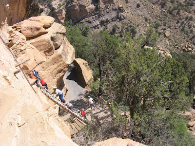
The Balcony House Trail is one of the most popular sites for visitors to Mesa Verde National Park in southwest Colorado. The 32 foot ladder climb entrance and 12 foot hands and knees tunnel exit make this the most adventurous of the alcove cliff dweller sites. It is also a site where the scarcity of water for the residents comes into focus.


As visitors arrive at the double ladder to climb into the north side of Balcony House, they brace themselves, eyes turned upwards, for the climb. Perhaps little noticed is the damp spot just to the right of the ladder. Mesa Verde is inclined to the south at about a seven degree angle. This slight slope is important in the formation of the alcoves that shelter the spectacular ruins sites like Balcony House.

Alcove formation is helped along by water that is absorbed into the porous sandstone and flows downwards until it reaches an impervious shale layer that forces the flow sideways. The cementing calcium carbonate dissolves and allows the sand grains to be washed or blown away. Seep springs are sometimes found in the back or near the alcoves and provide a convenient water source for the residents.

Though it doesn’t look like much, with the vegetation cleared away and with the use of pottery dippers and mugs, the use of this small spring would be preferable to walking a long distance and hauling a heavy load. Water weighst 8.34 pounds per gallon and in this dry climate 40 residents would need at least 400 pounds of water per day, maybe twice that amount.

When passing from the north parapet courtyard to the south courtyard with the two kivas, there is a glimpse of another seep spring at the back of the alcove. This spring is 30 feet or so above the spring that is visible at the ladder and appears to be contained in a small brick lined pool. There is also a view of this small water source just before the tunnel exit. The easily missed Geologic Overlook Trail, between Park Point and the Far View Visitor Center has a good view of the geologic layers at Mesa Verde and there is an interpretive sign there that discusses the formation and importance of seep springs.

The Mummy Lake constructed reservoir on the Far View Trail is an example of what had to be done if there were no springs nearby. The Mug House Trail tour includes a discussion of a constructed cistern to catch runoff to provide water for that large site. During the summer of 2010 Mesa Verde is installing new water pipes along the main park road. The water supply for the park is pumped up from the Jackson Lake north of Mancos, CO, after arriving at Jackson Lake through constructed canals that catch and control the snowmelt from the LaPlata Mountains. Throughout the ages, we go to great lengths to manage our water resources.

(There are other posts that show the details of Balcony House. Use the Balcony House Trail label to find.)