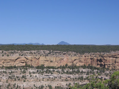
Tuesday, December 8, 2009

Cedar Tree and other Towers

The cliff dwellings are the most spectacular sights at Mesa Verde, but there are also mesa top ruins to see. The Cedar Tree Tower ruins site is an isolated Tower and Kiva site a little north of the Chapin Mesa Museum and the Spruce Tree Ruins area. This site is probably often skipped by those in a hurry to get to the more spectacular cliff dweller sites.

The tower location has a good view down a deep canyon. The interpretive information at the site raises the question of why were towers built. There are a lot of towers in the region but the reasons for them are not clear. The Cedar Tree Tower is connected to the adjacent Kiva with a tunnel.

We visit these sites mainly in the warm seasons of the year and forget that the residents had to endure the cold winters. Imagine a group of people sheltered in the Kiva under several feet of snow. A tunnel to a storage area with a way to get above the snow line seems like a practical arrangement.

Another tower that is easy to view at Mesa Verde is along the Far View Trail, a little north of the Cedar Tree and Farming Terrace area. There are several large sites at Far View, and I think it would qualify as a National Monument by itself if it wasn’t surrounded by the spectacular large alcove sites.

The Far Vew Tower is a little north of Far View House on the loop trail. The Far View Tower is surrounded by 16 rooms and there are two Kivas nearby. The trail guide for Far View says that nearly 60 round towers have been found at Mesa Verde. The three mentioned here are mesa top sites rather than alcove sites.

The longest Kiva and Tower combination found in the southwest is at Badger House on the Badger House Trail in the Wetherill Mesa part of Mesa Verde. The tunnel was built digging a trench which was then roofed with poles, brush and earth. This tunnel extended for 41 feet.


The Sun Temple site on the Mesa Top Pithouse to Pueblo Tour has a large circular tower.

Tower enthusiasts can find others in the Mesa Verde region. The Sand Canyon Trail in the Canyons of the Ancients west of Cortez, CO has one about 2.5 miles north from the south trailhead. Harder to get to is the Mad Dog Tower on the east side of Sand Canyon. The Sand Canyon area is very rich with small sites, at least 35 on the overall network of trails. The Hovenweep National Monument area is rich with towers, not all of them circular. The outlying Horseshoe Trail, Cutthroat Castle Trail, and Painted Hand Trail have good examples of circular towers.


Wednesday, September 30, 2009

Fall Color on the Prater Ridge Trail

The Morefield campground area at Mesa Verde has three hiking trails including the Prater Ridge Trail. The Prater Ridge Trail takes off from the south side of the campground area and climbs 675 feet up to the top of the ridge, and winds around along the edge. The other campground trails are the Knife Edge Trail and the  Point Lookout Trail.

It is 1.2 miles to the start of the two hiking loops on top of Prater Ridge. The north loop is 4 miles and the south loop is 2.4 miles. There is a shortcut trail that forms the two loops into a figure 8. From the north loop there are good views of several ranges of the nearby San Juan Mountains and the Montezuma and Mancos valleys below.

The south loop views are of the canyons along the main park road traveling toward the south part of the park. It is one of the few trails in the park that doesn't go past any of the 700 year old Ancestral Pueblo Ruins for which the park is famous.

In 2000, it was a bad year for forest fires at Mesa Verde. The Bircher Fire scorched the north side of the park near the Morefield campground. Mesa Verde means "green table" and for a while in 2000, it was a "black table".

The Gambel Oaks are recovering, bushy new shoots sprouting up around the charred remains of the forest fire victims. These oaks don't grow very tall, they grow more like a shrub here. In the fall the oaks put on a good display of color. The Utah Serviceberry shrub also adds some yellow to the scene.

The trail mostly follows along the sandstone cliffs. I scanned the cliffs to see if there were any small ruins sites but didn’t see any. It is possible that the people that lived here came to this area for materials as there were some Douglas Firs in the shaded north facing pockets and the acorns from the Oaks were probably a food source.
Most of the charred tree trunks from the forest fires are still standing. Most of what is visible now is the colorful oaks. There are only a few pockets where the evergreen trees survived. When I’ve hiked the full 7.4 mile loop it has taken me 3:30 hours. Hiking just the shorter 3.7 mile south loop route took about 2:15 hours.


Tuesday, August 11, 2009

Inaccessible House Trail

Inaccessible House is located below the east rim of Navajo Canyon in Ute Mountain Tribal Park in southwest Colorado. It is rarely visited, but is included on a special tour along with the nearby Casa Colorado ruins site. The trail head is in the area south of the Mesa Top Tour at the south end of Mesa Verde National Park. This hike has been offered once per year since 2009.

The trail runs south along the Navajo Canyon east rim to an unnamed side canyon where the Casa Colorado ruins sits at the side canyon head. A rough trail descends into the side canyon and turns back toward the main canyon and runs under the rim. The Inaccessible House site is above the trail at a somewhat awkward viewing angle, and seems to be very well preserved.

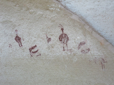
At the canyon junction a short distance before the site there are some historic inscriptions from some of the early visitors to the area. The 2009 hike was guided by one of the experts in the history of Mesa Verde and there was a good discussion of who the inscribers were and what their roles were in the early history of the area. There are several inscriptions on the canyon walls here.

The trail continues past the Inaccessible House site to another alcove that has only rubble piles remaining but also has a small reddish pictograph panel.

The wrecked nature of this alcove site was attributed to rough use during the pot hunter era of the early 1900s. This second site has several grinding and sharpening sites also.

Beyond the second alcove there is a small granary site. The trail along here was reasonably good despite not much maintenance over the years. The Ute Mountain Tribal Park has mostly left these sites in the state that they were found. Pottery shards are visible and remain in place as all hikes here are guided. I noticed a second granary site on the return hike near the inscription rock, so there are three intact ruins in this area plus the pictograph alcove.

Inaccessible House doesn’t appear to be a place that anyone would have resided in, maybe it is a special use site. It is hard even to see it.

The quality of the stonework seems to be particularly fine here. The stones that are visible seem to be very well shaped.
There isn’t any room to step back and get a good view. Our tour group visited this site and those with enough energy left continued on to nearby but harder to get to Casa Colorado. On the 2011 hike the order of the visits was reversed. Casa Colorado was visited first. Casa Colorado is an easier site to view but the trail to Inaccessible House has more features.

On the 2011 return hike, there is a view point for Inaccessible House from the rim. The total tour in 2009 took about 6:30 hours with about half the time spent at each of the two sites. The 2011 tour took about 5:00 hours, with less time spent on Casa Colorado. The distance covered was about 3 miles but the route was somewhat difficult and required some scrambling up and dwn in the rocky environment.

Sunday, August 9, 2009

Casa Colorado Trail

Casa Colorado is a rarely visited Ancestral Pueblo cliff dweller ruins site in Ute Mountain Tribal Park in southwest Colorado. Ute Mountain Tribal Park offers guided full day and half day tours and a few special tours such as this hike to Casa Colorado and Inaccessible House. The 2009 summer season was the first year this hike was offered and it was offered once also in 2010 and 2011.


The trail head area for Casa Colorado is accessed at the south end of Mesa Verde National Park in the vicinity of the Mesa Top Pit House to Pueblo self guided tour. This is the same beginning area for the Pool Canyon Trail, another of the rarely offered Ute Mountain tours. After a short drive across the park boundary the hike begins along the east rim of Navajo Canyon.

The popular Spruce Tree Canyon area is a side canyon to the north of this section of larger Navajo Canyon. The hike along the rim is about 0.5 miles to an unnamed side canyon with Casa Colorado at the head of this short side canyon.

There were at least 3 ruins sites visible across the Navajo Canyon the west side. One of them we thought was named Casa Blanca and there also appears to be a tower visible. You would need binoculars to see these distant sites very well. At the canyon bottom there appears to be an old road.

There is an old 1930s era trail just below the rim heading east to toward the ruins site but it is unmaintained and wasn’t obvious on the outward leg. In 2009, most of our group made their way slowly through the Pinon Pine and Juniper forest but mostly not on any trail. The route was somewhat difficult and there was some scrambling through and over the jumbled rocks. The distance was only about 0.3 miles and the ruins site was visible most of the way.

On the 2011 hike to Casa Colorado, the tour stayed on the north rim of the side canyon and circled around the canyon head, then approached the Casa Colorado site from the south side. Those who wanted could try to descend down to the next ledge and view the site from the right side.

Casa Colorado is difficult to approach no matter which way you try. The 2011 approach involved some tricky climbing.

The trail approaches from the left side. It was possible, though not easy, on the 2009 hike, to approach the Casa Colorado closely from the right side by descending to the canyon bottom and climbing up the other side. It looked like the right side would have been the main entrance.

In 2009, a few of our active group chose to climb to the canyon rim from this right side of the site, going out over the top of the ruin, but most returned back the way we came. In 2011 the right side climb was the guided way in. The return trip was a little easier, and was mostly on the old trail below the rim.

The total hike to Casa Colorado and nearby Inaccessible House was about 6:30 hours with about half the time spent at each site. The total distance was only about 3 miles but the going wasn’t easy and there was a lot of lingering at each site.


18407_$5 Shipping on Orders of $99 or More! 544544_$20 off any hotel booking of $350 or more with code TLSALE20

Friday, June 19, 2009

Long House Trail

The Long House Trail is on the Wetherill Mesa side of Mesa Verde National Park in southwest Colorado.

This section of the park is only open during the summer months and has the second largest concentration of Ancestral Pueblo ruins in the park. Long House is the second largest cliff alcove site at Mesa Verde.
Long House can only be visited on a $3, 1.5 hour ranger guided tour. After arriving at the Wetherill Mesa parking area, visitors take a tram to the trail head. There is one stop on the paved trail leading down into the large alcove site. In addition to a discussion of the Pinon Pine and Utah Juniper forest environment a small water conserving check dam along a small drainage is pointed out.

Long House is one of the sites that early investigator Gustavf Nordenskiold visited in 1891 and he labeled this site No. 15, the carving still visible in the sandstone as the tour enters the site. Also visible on the way down are hand and toe holds that residents must have used to climb to the canyon rim.
The Long House tour includes visiting the back of the site after climbing two ladders. In the cool and shady back of the alcove there was a discussion of the advantages and reasons for building and living in the alcoves after centuries of living on the mesa tops. My favorite reason is the shelter from the hot summers and cold winters that the south facing alcoves provided.

There is a seep spring providing water at the back of the cave and small hollowed out basins where water could collect are visible. It is thought that construction started at the back of the site and expanded towards the front. There are also examples of grain grinding stones on display in the back.

There are 21 kivas at Long House, one still having part of the roof intact. There is a ladder to climb up and view inside. Standing in the elevated area at the back, the kivas seem to cascade down to the lower plaza area below. The kivas are thought to have been useful for winter protection and also served ceremonial purposes. There are a few small rock art pictographs along the back wall.
Among the 150 rooms at Long House there are some upper level storage areas. Looking up at these storage areas it is hard to see how anyone was able to get up there.

The last stop is in the large plaza in the lower front of the site. The ranger had the group close our eyes imagine the scene of a major dance ceremony taking place; drums playing, fires burning, viewers watching from the canyon rim, an exciting evening.

The 12 miles drive to Wetherill Mesa from the Far View Visitor Center has several pull over view points along the twisty road. At the three that are closest to the end of the road, small ruins sites are visible across the canyons. These smaller sites tend to get lost among the very large sites for which Mesa Verde is famous. One of the three is a tower that seems to sit isolated on the opposite rim, much like the Cedar Tree Tower in the Chapin Mesa area.


Tuesday, May 26, 2009

Knife Edge Trail and Spring Wildflowers

The Knife Edge Trail at Mesa Verde National Park in southwest Colorado is one of two or three interpretive trails in the park that emphasize the plants found in the area, and their use by the Ancestral Pueblo people that lived here.

The Trail Head is in the Morefield campground area near the part entrance and the hike is a 2.0 mile round trip. There are three hiking trails starting in the Morefield campground area, but none of them pass by any of the famous ruins sites.

There are 32 stops on the self guided trail. In spring, not all of the plants mentioned in the trail guide are in flower, but some are. The first stops on the trail are Gambel Oak and Pinon Pine, two of the most common trees, and also sources of acorns and pine nuts that were edible. Also mentioned are Black Sagebrush and Big Sagebrush, two common shrubs. Big Sagebrush is an indicator of good soil for farming.

In the vicinity of the marker that discussed the blue Spurred Lupine there was a blue flower in bloom, but I think in late May is was Larkspur.

There are some wildflowers along the trail that aren't mentioned in the trail guide. I think this is Clematis in the buttercup family. Clematis is one of the plants identified on the paved trail leading down to Spruce Tree House on Chapin Mesa.

Another flower that was conspicuous in May but not mentioned in the trail guide was this showy white flower that I think is Cliff Fendler Bush. The views from the Knife Edge Trail are from the North Rim of Mesa Verde toward the Montezuma Valley.

Snowberry is a low growing bush with pale pink bell shaped flowers. The Trail Guide says that there was no known Ancestral Pueblo use for Snowberry. Another berry on the trail is Utah Serviceberry, the most common bush in Mesa Verde and probably a source of food. There is also an Elderberry Bush on the trail, the only one that has been found in the park.

The Trail Guide mentions that this bush was so striking that the Knife Edge road was detoured slightly to preserve it. The Knife Edge Road was built in 1914 and served as an entrance to the park until the tunnel between Prater and Morefield canyons was built in 1957.

The Wild Rose has bright pink flowers and red oval shaped berries called "hips." These hips are rich in vitamin C and some have been found in Ancestral Pueblo remains. These roses grow in moist side canyons in dense patches.

A few small Douglas Firs are found along the trail and there are large ones high above against the north facing cliffs. Douglas Firs are also found in the moist canyons such as near Spruce Tree House. The Trail Guide mentions that the most colorful flower along the trail is the bright red Indian Paint Brush, but in late may none were in bloom yet.

Friday, May 8, 2009

Inside Balcony House

The one hour tours at Balcony House at Mesa Verde National Park in southwest Colorado begin in late April, about three weeks after they begin at the famous Cliff Palace. Balcony House is a medium sized 27 room cliff dwelling and is very popular as the tour visit involves the adventure of climbing several ladders and crawling through a short tunnel.

Another difference about the Balcony House tour is that the visitor goes deep inside the sandstone alcove, rather than just along the front. The tour has five stops. There is an introduction at the beginning, a pause and view before descending a metal stair case and another pause before climbing the 32 foot double ladder. The fourth stop is in the plaza area where the well preserved balcony is visible.

After the discussion in the plaza, the route to the other side of the site involves a short climb and maneuvering around behind the structures to the back of the alcove, something that the other large alcove sites don’t allow.
The back of the alcove has a seep spring that provided water for the site. The Balcony House is a little unusual in that it faces mostly east rather than south, and doesn’t catch much sun in the cold winter months. The back of the alcove is thought to have been a refuse disposal area.

The fifth and last stop is in the area where the two site Kivas are side by side. These Kivas seem to be particularly deep and perhaps the extra insulation made up for the lack of solar heating here. Near the exit, there is a display of grinding stones that would have been used to grind corn.

Some of the ranger discussion talked of how these people suffered from decayed teeth. Sand from the corn grinding would end up in their food and wear their teeth down. The other observation was the prevalence of arthritis, from the kneeling and probable carrying of materials in a difficult location. There has been little observation of signs of violence.

The highlight exit is to crawl on hands and knees through the 12 foot tunnel. This was the entrance and exit that the people who lived here used. The entrance the tour uses was engineered by the Park Service.

Looking down on the tunnel from above, it appears that it was originally just a narrow crack in the sandstone. It looks like a ceiling was added to the crack and the gap filled with masonry. Some effort was made to make the site secure from unwanted visitors and this is one of the mysteries of the cliff dwellings.

Some sites show signs that security was a concern, but others do not. After visiting Balcony House, the nearby Soda Canyon Trail offers a 1.2 mile hike through the Pinon Pine and Utah Juniper forest to three canyon overlooks. From the first two overlooks, there are somewhat distant views of Balcony House.


Sunday, April 12, 2009

House of Many Windows View Point


The House of Many Windows Trail is a 3 (or maybe 6) mile segment of paved road along the Cliff Palace Loop that visits five overlooks and has a continuous cross canyon view. This is an off season hike. Most summer visitors pass by the middle view points after visiting Cliff Palace or heading to Balcony House.

After the first week of November, the Ranger guided tours at Cliff Palace and Balcony House close for the season. The road remains open until it is impassible with snow. I started my mid November hike at the Cliff Palace parking area. The road was still open and there was very little traffic. The stunning Cliff Palace is always worth a quick view from the overlook area.

The first viewpoint after Cliff Palace is the Cliff Canyon Overlook. This point is across the canyon from Sun Point which is one of the best ruins view points in the region, with up to 12 sites visible. To the right on the same side of this canyon rim is a side view of Sunset House.

Looking across the canyon, there are three ruins sites visible. Sun Point Dwelling, to the right has only three rooms along a narrow ledge. Site 634 in the middle, has 16 rooms and two kivas. Way to the left is the House of Many Windows.
The second lookout point gives a more direct view of the House of Many Windows. The multiple openings are actually doors. The site is thought to have 11 rooms and maybe a kiva. From this point there is a view up the canyon toward the Sun Temple and a glimpse of Oak Tree House.

The paved road turns east and the scene shifts from Cliff Canyon to Soda Canyon. Right at the turning point, there is a segment of old paved road that offers better views than the main road. It appears that the road was abandoned because it cut too deeply into the adjacent Ute Mountain Tribal Park. I followed the abandoned road which stayed along the canyon rim. It rejoins the main road at the next lookout point.

The next lookout point is for Hemenway House, named for Mary Hemenway, a Massachusetts woman who financially supported the early archaeological research in the southwest. The site named for her is spread out in a very large alcove.

The next view point is the Balcony House parking area, though Balcony House isn’t visible. The tour of Balcony House is popular and features ladders to climb and a short tunnel to crawl through. Further up the road the 1.2 mile Soda Canyon Trail leads to two overlook points that offer the only views from outside balcony House.

After the Soda Canyon Trail, the road loops back to Cliff Palace. My hike, with the road open was about 3 miles and I spent about 2:00 hours. If the road is closed, the distance to make the loop increases to 6 miles. I walked on a 40 F degree blue sky day in mid November.

Saturday, April 11, 2009

Small Ruins on the Farming Terrace Trail

The Cedar Tree Tower and the 0.5 mile Farming Terrace Trail are located along a short side road near the Chapin Mesa Museum area in Mesa Verde National Park in southwest Colorado. This pair of attractions is probably often overlooked.

The Cedar Tree Tower location has a good view down a deep canyon. The interpretive information raises the question of why were towers built. This tower is in good position for signaling, but there is not another obvious tower in sight.

There are a lot of towers in the region, particularly in the Hovenweep National Monument, but the reasons for them are not clear. The Cedar Tree Tower is in combination with a circular kiva and there is a connecting tunnel. There is another tower and kiva combination on the Badger House Trail on the Wetherill Mesa part of Mesa Verde.

Nearby Cedar Tree Tower the short Farming Terrace Trail winds around a dry wash area. The Pinion Pine and Utah Juniper trees along the trail are scorched from the recent forest fires. The highlight of this trail is the series of check dams built across the gully to catch runoff and limit erosion in a dry climate. It is pointed out that in dry years these check dam areas provided more moisture for agriculture than the mesa top fields.

Upstream of the check dams there is a small ruins structure. This site isn’t pointed out and isn’t visible from the trail, though it is very close by. The Cedar Tree Tower is visible across the drainage, through the burnt over forest. It makes sense that some sort of a dwelling would be in the vicinity of the farming terraces.

This site looks like it has been excavated recently as there are piles of sandstone bricks nearby. The extensive forest fires that have occurred since 2000 are said to have revealed many previously unknown sites, and perhaps this is one. It makes an interesting addition to this short trail.